Thomas D. Andrews, Steven V. Kokelj, Glen MacKay, Julie Buysse, Ingrid Kritsch, Alestine Andre, and Trevor Lantz
Permafrost Thaw and Aboriginal Cultural Landscapes in the Gwich’in Region, Canada.
APT Bulletin Journal of Preservation Technology 47 (1): 15-22. 2016.
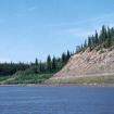
Abstract: Throughout the Western Arctic, the thawing of ice-rich permafrost is leading to significant thermokarst landscape disturbance, which is in turn impacting cultural resources. Assessment and monitoring of the extent of impacts to cultural resources from climate change-induced landscape erosion is hampered by the vast and remote geography of the Northwest Territories, yet heritage managers are in need of a way to identify areas where the risks from these processes are greatest. In this paper we describe the integration of traditional land use data and information on retrogressive thaw slump density to create a GIS-based heritage risk assessment for the Gwich’in cultural landscape in northwest Canada. Our results indicate that the greatest risk to Gwich’in cultural resources from thaw slumping occurs along the Peel Plateau, while areas adjacent to the Mackenzie River and Delta appear to be at lower risk of impact from this process. It is hoped that the risk map can be used to assist in prioritizing management actions for climate change impacts to cultural resources in this area.